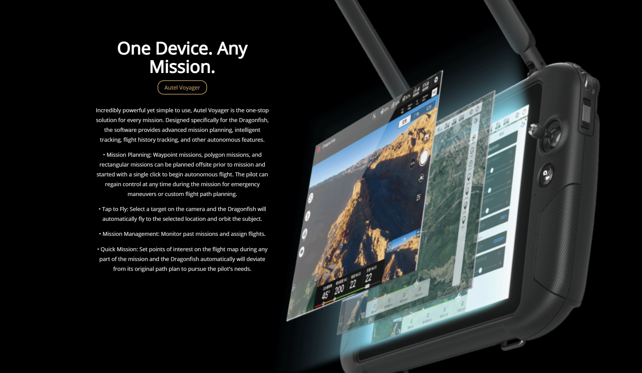
“Fantastic course with very experienced instructors. Highly recommended.”
“Very good experience with the Drone Pilot Academy. As someone who had never operated a drone before, I was a bit apprehensive about piloting. However, the quality and experience of the instructors, especially Chris, were crucial in teaching the basics of flying a drone safely, which greatly boosted my confidence.
The entire course was well organized and of high quality, showing great attention to the students. Jim and the team deserve congratulations for this.”
“Chris Wright the Head of Training is extremely knowledgeable and fluid in his teaching. He has the answer to every possible question and helped everyone pass the exams first time. Highly recommend.”
“Very easy comms with Jim to organise the DJI mini 4 drone training. He sent through a lot of info about what IDs and Apps are needed or recommended. Great place for the training, we had a great time and are much better prepared and confident as a result. No showing off with the drones, just a straightforward professional person. 5/5 👍”
“Myself and two colleagues attended the 3 day GVC
training course to obtain our GVCs in 2023. All accommodation, food etc. was all included in the price which made for a very enjoyable experience. Chris and Richie are very knowledgeable, helpful and approachable. There were full days of teaching the required theory and practical flights, however on the last day we had adverse weather so couldn't complete the FA. A year went by and we still hadn't due to various work commitments etc.. but they were very understanding and accommodating of us and over a year later were happy to support, meet and ultimately guide us through in obtaining our GVCs. I can't rate these guys highly enough and would not hesitate in recommending them for any drone training you would want to undertake.”
“Highly Recommend!
Top-Notch Training!
I recently completed the residential A2CofC and GVC course with Drone Pilot Academy, and I can't recommend them enough!
Pros:
Immersive Learning: The residential format provided a focused learning environment, allowing me to fully grasp the course material.
Expert Instruction: Chris our instructor was ex-RAF with a wealth of knowledge. His revision exercises in the classroom were invaluable for exam preparation.
Convenient Exams: Taking both exams in the classroom after the course was a huge plus. It eliminated any time lag and was good to crack on an get the exams completed.
Flight Assessment: There was plenty of time included for practical flight training and practice. I had my FA on the same day of the exams but there is no pressure to do that, it was convenient for me and I had enough flying hours to progress.
Streamlined Process: Drone Pilot Academy took care of everything, making the entire experience smooth and hassle-free.
Overall: This residential course was the perfect choice for me. It offered intensive training, expert guidance, and a convenient exam process. If you're looking to get your A2CofC and GVC in a supportive and immersive environment, Drone Pilot Academy is the way to go!”
“Thoroughly enjoyed the course, very professional, the instructor’s knowledge in this industry is second to none. Highly recommend”
“I found this course disappointing. Despite being in a group with six others from a different company, I received less flight time compared to them. The course structure felt disorganised, and the instructor appeared frustrated as I struggled to grasp the material.”
“From taking on their courses and their additional advice and support given in regards to setting up afterwards has all been very thorough and helpful. Such a great and professional team to know as they never fail in steering you in the right direction with whatever it may be you seek within the drone industry!”
“Totally recommend! Thanks Chris. Very patient and takes time to explain ! ( yes Totally recommend for that matter, I have already sent a friend of mine your way. He will contact you soon.)”
“From Mike Ghent. A joy to be trained by professionals. With a real passion for the subject matter and the skills to impart knowledge and confidence. A great training experience with continuous assistance and support through the course, assessment, and beyond. Many thanks”
“I need a GVC qualification to work on the UK's Polar research vessel in the Antarctic and Arctic. I was a little nervous about the subject matter of the course and my capacity to learn all of the info in just 3 days but Chris at DPA was simply excellent with his course plan and delivery/time management. It was a thoroughly enjoyable course and I would recommend, 10/10 training provider. Additionally if you are staying at the hotel the food/lunch is excellent.”
“Great instructors making a lot of hard info go in. Excellent company.”
“I deliberately chose a face-to-face training course for my GVC; for me there is massive value in having the ability to ask the tutor questions as they arise, and DPA organise things so that you can continue in the bar after the teaching has closed for the day. Hard work for an old man who has forgotten how to concentrate in a classroom, but ultimately successful. Chris Wright is very knowledgeable and experienced, a good teacher most generous with his time . Highly recommended.”
“I wanted to expand my understanding of Drone operations, so I booked a GVC with the Drone Pilot Academy. An excellent three day course, delivered with great instruction (patient and very knowledgeable) at a great venue. Course material was very good and post course support was excellent. If you are considering doing some Drone training then this is place I would recommend.”
“Excellent training and still giving me support and advice over a year after my course, including reviewing Op Manuals . I strongly recommend them!”
“I am really happy with the course and the instructors on the course, learned a lot, and have helped me achieve what I need to go further. Greatly appreciated.”
“Wanted to try a bit of a taster session flying drones and seeing the art of the possible. Jim was excellent, and provided lots of knowledge and guidance, completely made me feel comfortable with my first drone flight.
Would highly recommend!”
“It has been a pleasure working with Drone Pilot Academy from the very first day. HVAC Communications was looking to introduce drones into the business and Jim from DPA spent time with us explaining what we would need to operate, demonstrated different drones and set everything up for us. The GVC course was delivered very professionally by Chris over three days with him going above an beyond to answer any questions put forward. The guys are very knowledgeable and their experience and previous RAF careers show through. The post course support has been great. We will definitely continue to use DPA in the future.”
“Completing a PFcO to GVC course in November 2023, with The Drone Pilot Academy, who I had also got my original PFcO drone licence with previously. 1 day course with James Ixer, who has a professional and friendly approach to his courses.
I would recommend this company, for those considering getting into the Drone sector, for qualifications and training etc.”
“I attended the PfCO to GVC conversion course with Drone Pilot Academy last week and have to say how professionally it was put together. Jim is extremely knowledgeable and passionate, he gets the lesson across expertly and immediately putting you at ease. This is the second time I have gone to DPA for training and wouldn't consider going anywhere else. I can highly recommend them to anyone who has an interest in Drones. Thanks Jim and all at DPA”
“I was looking for a course to obtain my drone qualification to help with roof surveying and I was recommended to attended the 3 day course for the GVC and A2 CofC.
On attendance the course was very educational by providing a full understanding of the requirements for drone flying. The material was easy to follow and any questions we had were promptly answered.
There was a test on the third day which the whole class had passed. After the test we attended a field near by to practice flying a drone.
After the class, the service was still present with help organising the flight test and the paperwork required to submit to the CAA.
I would highly recommend attending a course via the Drone Pilot Academy if you require a qualification or are a beginner to drone flying. I will definitely be attending the infrared foundation course in the near future.”
“I have recently completed Drone Pilot Academy's A2 CofC and GVC courses along with several colleagues. A special shout out to Richie for sharing his experience, knowledge and skills, ensuring you're well-prepared for your journey into the skies. From understanding airspace regulations to mastering flight maneuvers, it's a fantastic experience. They've incorporated all the right elements for success. Highly recommend for all aspiring drone pilots!”
“I recently attended the GVC drone pilot course with Drone Pilot Academy.
Thoroughly enjoyed the three day course.
My instructor was extremely knowledgeable and passionate about the subject, would defiantly recommend to anyone who has interests in drones, whether commercially or just for fun.”


