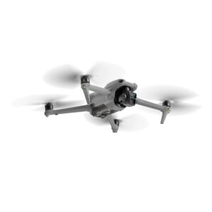
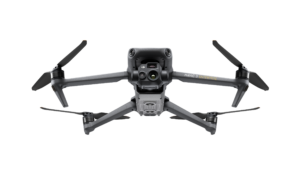
The EVO Max 4T brings powerful technologies and advanced autonomy to users. EVO Max 4T assesses complex environments to create real-time 3D flight paths for unparalleled obstacle avoidance. Advanced sensors make flight in GPS unavailable areas possible and the incredible new thermal payload unlocks new object identification and tracking scenarios. With a foldable, weather-resistant design, the EVO Max 4T is as portable as it is capable.
Hybrid Sensor Payload
The EVO Max 4T payload integrates wide-angle, zoom and thermal camera with a laser rangefinder for all data capture needs and critical decision making.
Laser Rangefinder Tap a target to get the coordinates and altitude rapidly from up to 0.75 miles away.
Thermal Camera Equipped with 640×512 high-resolution radiometric thermal imaging camera, 30fps and 16x digital zoom.
Wide Camera Autel’s Moonlight Algorithm 2.0 boosts post-processing and allows the pilot to capture crisp, detailed images in low-light environments.
Video: support 4K 30fps, max ISO 64000.
Photo: Moonlight mode reduces noise and enhances HDR.
Zoom Camera Supports for 8K 10x optical zoom and 160x Max. Hybrid Zoom with clear details on targets up to 1.24 miles away.
A Leader in Drone Intelligence
The EVO Max 4T comes equipped with a wide array of features and capabilities that range from Autonomous Path Finding, Navigation in GPS Denied Environments, and Accurate Object Identification and Tracking.
Autonomous Path Finding Autel’s Autonomy Engine collects surrounding environmental data and plans 3D flight paths through complex environments such as mountains, forests, and buildings. Use cases include rapid 3D scene reconstruction, public safety overwatch, industrial inspection, and land surveying.
Navigation In GPS Denied Environments Advanced sensors allow the EVO Max 4T to navigate within hardened structures, underground, or in environments without GPS.
Accurate Object Identification And Tracking Based on Autel’s AI recognition technology, the EVO Max 4T can automatically identify and lock onto different types of targets such as heat sources, moving people, or vehicles and achieve high-altitude tracking and data collection for law enforcement personnel.
No Blind Spots
Ultimate Obstacle Avoidance
EVO Max 4T is the only commercial drone that combines traditional binocular vision systems with millimeter wave radar technology. This allows the EVO Max 4T’s onboard Autel Autonomy Engine to perceive objects down to 0.5 inch, eliminating blind spots and enabling operation in low light or rainy conditions.
Anti Jam, Anti Interference
The EVO Max 4T uses advanced flight control modules and algorithms specially designed to counter RFI, EMI, and GPS spoofing. This enables the EVO Max 4T to fly confidently near power lines, critical structures, and in complex areas.
Weather Rating-IP43
Platform Capability
EVO Max 4T redefines portability with its powerful platform and all weather design.
It comes equipped with the following features and capabilities:
42 Minutes of Maximum Flight Time
IP43 Ingress Protection Rating
27 mph Maximum Wind Resistance
23,000ft Service Ceiling
12.4 Mile Transmission Range
*Takeoff and landing can withstand wind speeds up to 27 mph (12 m/s).
Hot-Swappable Battery
Autel Max 4T hot-swappable battery system, which allows for extended flight times without the need for downtime. This system allows users to easily swap out batteries while the drone is still in operation, making it ideal for use in time-critical applications where every second counts.
A-Mesh 1.0 — The Drone Industry’s First Mesh Networking Technology
EVO Max 4T features the new A-Mesh system, enabling drone-to-drone autonomous communication, connection, and collaboration.
The EVO Max 4T features the new A-Mesh system, enabling drone-to-drone autonomous communication, connection, and collaboration for seamless enterprise operations.
Strong Anti-Interference The EVO Max 4T can communicate seamlessly with other drones in the vicinity, unlike a traditional chain structure. If a single drone fails or exits unexpectedly, the entire system will independently self-organize and continue to relay critical information.
Beyond-Line-of-Sight Applications With A-Mesh, multiple aircraft in the vicinity can act as relay points to greatly improve BVLOS operation effectiveness.
Full-Fleet Control Multiple drones can be controlled autonomously by one pilot or by a group of pilots simultaneously with or without LTE coverage.
Enhanced Range Communication nodes can be placed statically on hills or poles to provide full coverage to an area, or a swarm of drones can provide mobile communication points to extend the coverage of the entire group.
Autel SkyLink 3.0
The EVO Max 4T SkyLink 3.0 system comes with 6 antennas, 4 frequency bands, AES-256 encryption, and optional 4G integration to provide users with the most advanced flight capabilities ever in an EVO.
12.4 Mile Image Transmission Range
1080p/60fps Real-Time Image Quality
900MHz/2.4GHz/5.2GHz/5.8GHz Frequency Bands**
<150ms Latency
*This feature will be available in a future update. **5.2GHz is only applicable for FCC, CE, and UKCA regions. 900MHz is only applicable for FCC regions.
Autel Enterprise App Platform
The Autel Enterprise App is built from the ground up for industrial applications and features a brand-new interface for simple, efficient operation. Additional features and semi-autonomous modes maximize the EVO Max 4T’s mission capability.
Smart Features
The EVO Max 4T comes equipped with the following intelligent features that were tailored for commercial end users:
3D Map Planning Plan, create, and execute 3D waypoint mission plans on a 3D map.
Mission Reproduction* Fly a manual or semi-autonomous mission, or string multiple missions together. The EVO Max 4T will automatically record the camera angles and replicate the mission you just flew.
Quick Mission* Temporary quick missions can be created while executing other missions, and multiple sub-missions can be stacked for enhanced flexibility.
Multiple Mission Types
The Enterprise App provides various autonomous and semi autonomous mission planning for public safety, inspection, and surveying.
Waypoint Missions Users can add waypoints for flexible, non-structured flight paths.
Rectangular Mission Supports one-click automatic generation of a rectangular flight area.
Automatic Mission (Generation And Data Capture*) Automatically produce routes by adding regional boundary points through dots or importing KML files.
Terrain Follow* Maintain a relatively constant altitude from the ground for uneven or sloped terrain.
Oblique Photography Automatically plan 5 groups of routes (1 ortho + 4 oblique) according to the flight area set by the user.
Spiral Mission* Supports helical flight search in a designated area for SAR.
Polygon Mission Supports one-click automatic generation of polygon flight areas.
Vertical Scan* Perform vertical surveys for building facades, open pit walls, and towers.
Corridor Mission* Supports intuitive and effective corridor mission planning for roads, rivers, pipelines, power lines and other narrow, large-scale terrain.
*This feature will be available in a future update.
Data Security
Featuring AES 128/256 storage, radio link and network encryption for operational security.
Privacy Protection: Data involving user and aircraft information, including flight logs, locations, and account information can only be physically accessed via the aircraft locally.
Encrypted Data Storage: Supports AES-256 encryption for photos, videos, and flight logs, are password-protected.
Enhanced Live-View
Multi-channel Projection Screen* Supports simultaneous output of RGB, infrared, night vision, and wide-angle images.
AR Scene* Geo-location data and other aircraft location info detected by ADS-B can overlay on real-time map, which is convenient for users to confirm the drone’s location and avoid airborne risks.
*This feature will be available in a future update.
Complete Remote Operations System
Used with the EVO Nest, the EVO Max series supports all-weather auto piloting for scenarios such as substations, industrial parks, and rooftops.
Autel SDK
The Autel SDK is open to the world, helping developers and partners reduce software and hardware development costs and jointly create a new industry ecosystem.
Mobile SDK Open UX SDK (iOS & Android) can directly call up the ready-made interactive interface.
Payload SDK* Unified interface standards support access to third-party mounts such as microphones and gas detectors.
Cloud SDK* Enables remote live broadcast and control of drones and Nests through third-party platforms or web pages.
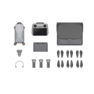
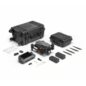
Accessories
Autel Smart Controller V3 Daylight Readable Display: 7.9 inches, 2000nit maximum brightness, 2048*1536 resolution. SuperDownload: Download footage from drone to mobile device at a maximum rate of 20MB/s. Functional Interface: HDMI ports allow connection to 3rd party displays or monitors. Ultra-Long Battery Life: Up to 4.5 hours of continuous operation. 2-hr fast charging from empty. Local Storage: Built-in 128G storage space allows 3rd party apps and mission media storage.
Live Deck 2 (optional) Broadcast live mission intel to other personnel in the operation for enhanced situational awareness and critical decision-making without the need for LTE connection. The EVO Max 4T is compatible with Live Deck 2, which offers multiport streaming to monitors and Wi-Fi support for multiple local smart phones.
RTK Module (optional) Provides centimetre-accurate positioning data for mapping and reduces electromagnetic interference for flying near critical structures.
Application
The Autel EVO Max 4T was designed for survey and inspections, search and rescue operations, public safety, and many other commercial applications.
Features
8K 10x Optical Zoom
Thermal Camera:640×512 | 16x Digital Zoom
Wide Camera: 50MP | 1/1.28? CMOS
Zoom Camera: 48MP | 8K 10x Optical Zoom(160x Max)
Laser Rangefinder
Autel SkyLink 3.0 | 12.4 miles Transmission Range
720° Obstacle Avoidance
42 mins Max Flight Time
A-Mesh 1.0 | Mesh Networking Technology
3D Map Planning | Multiple Mission Types | Data Security
“Fantastic course with very experienced instructors. Highly recommended.”
“Very good experience with the Drone Pilot Academy. As someone who had never operated a drone before, I was a bit apprehensive about piloting. However, the quality and experience of the instructors, especially Chris, were crucial in teaching the basics of flying a drone safely, which greatly boosted my confidence.
The entire course was well organized and of high quality, showing great attention to the students. Jim and the team deserve congratulations for this.”
“Chris Wright the Head of Training is extremely knowledgeable and fluid in his teaching. He has the answer to every possible question and helped everyone pass the exams first time. Highly recommend.”
“Very easy comms with Jim to organise the DJI mini 4 drone training. He sent through a lot of info about what IDs and Apps are needed or recommended. Great place for the training, we had a great time and are much better prepared and confident as a result. No showing off with the drones, just a straightforward professional person. 5/5 👍”
“Myself and two colleagues attended the 3 day GVC
training course to obtain our GVCs in 2023. All accommodation, food etc. was all included in the price which made for a very enjoyable experience. Chris and Richie are very knowledgeable, helpful and approachable. There were full days of teaching the required theory and practical flights, however on the last day we had adverse weather so couldn't complete the FA. A year went by and we still hadn't due to various work commitments etc.. but they were very understanding and accommodating of us and over a year later were happy to support, meet and ultimately guide us through in obtaining our GVCs. I can't rate these guys highly enough and would not hesitate in recommending them for any drone training you would want to undertake.”
“Highly Recommend!
Top-Notch Training!
I recently completed the residential A2CofC and GVC course with Drone Pilot Academy, and I can't recommend them enough!
Pros:
Immersive Learning: The residential format provided a focused learning environment, allowing me to fully grasp the course material.
Expert Instruction: Chris our instructor was ex-RAF with a wealth of knowledge. His revision exercises in the classroom were invaluable for exam preparation.
Convenient Exams: Taking both exams in the classroom after the course was a huge plus. It eliminated any time lag and was good to crack on an get the exams completed.
Flight Assessment: There was plenty of time included for practical flight training and practice. I had my FA on the same day of the exams but there is no pressure to do that, it was convenient for me and I had enough flying hours to progress.
Streamlined Process: Drone Pilot Academy took care of everything, making the entire experience smooth and hassle-free.
Overall: This residential course was the perfect choice for me. It offered intensive training, expert guidance, and a convenient exam process. If you're looking to get your A2CofC and GVC in a supportive and immersive environment, Drone Pilot Academy is the way to go!”
“Thoroughly enjoyed the course, very professional, the instructor’s knowledge in this industry is second to none. Highly recommend”
“I found this course disappointing. Despite being in a group with six others from a different company, I received less flight time compared to them. The course structure felt disorganised, and the instructor appeared frustrated as I struggled to grasp the material.”
“From taking on their courses and their additional advice and support given in regards to setting up afterwards has all been very thorough and helpful. Such a great and professional team to know as they never fail in steering you in the right direction with whatever it may be you seek within the drone industry!”
“Totally recommend! Thanks Chris. Very patient and takes time to explain ! ( yes Totally recommend for that matter, I have already sent a friend of mine your way. He will contact you soon.)”
“From Mike Ghent. A joy to be trained by professionals. With a real passion for the subject matter and the skills to impart knowledge and confidence. A great training experience with continuous assistance and support through the course, assessment, and beyond. Many thanks”
“I need a GVC qualification to work on the UK's Polar research vessel in the Antarctic and Arctic. I was a little nervous about the subject matter of the course and my capacity to learn all of the info in just 3 days but Chris at DPA was simply excellent with his course plan and delivery/time management. It was a thoroughly enjoyable course and I would recommend, 10/10 training provider. Additionally if you are staying at the hotel the food/lunch is excellent.”
“Great instructors making a lot of hard info go in. Excellent company.”
“I deliberately chose a face-to-face training course for my GVC; for me there is massive value in having the ability to ask the tutor questions as they arise, and DPA organise things so that you can continue in the bar after the teaching has closed for the day. Hard work for an old man who has forgotten how to concentrate in a classroom, but ultimately successful. Chris Wright is very knowledgeable and experienced, a good teacher most generous with his time . Highly recommended.”
“I wanted to expand my understanding of Drone operations, so I booked a GVC with the Drone Pilot Academy. An excellent three day course, delivered with great instruction (patient and very knowledgeable) at a great venue. Course material was very good and post course support was excellent. If you are considering doing some Drone training then this is place I would recommend.”
“Excellent training and still giving me support and advice over a year after my course, including reviewing Op Manuals . I strongly recommend them!”
“I am really happy with the course and the instructors on the course, learned a lot, and have helped me achieve what I need to go further. Greatly appreciated.”
“Wanted to try a bit of a taster session flying drones and seeing the art of the possible. Jim was excellent, and provided lots of knowledge and guidance, completely made me feel comfortable with my first drone flight.
Would highly recommend!”
“It has been a pleasure working with Drone Pilot Academy from the very first day. HVAC Communications was looking to introduce drones into the business and Jim from DPA spent time with us explaining what we would need to operate, demonstrated different drones and set everything up for us. The GVC course was delivered very professionally by Chris over three days with him going above an beyond to answer any questions put forward. The guys are very knowledgeable and their experience and previous RAF careers show through. The post course support has been great. We will definitely continue to use DPA in the future.”
“Completing a PFcO to GVC course in November 2023, with The Drone Pilot Academy, who I had also got my original PFcO drone licence with previously. 1 day course with James Ixer, who has a professional and friendly approach to his courses.
I would recommend this company, for those considering getting into the Drone sector, for qualifications and training etc.”
“I attended the PfCO to GVC conversion course with Drone Pilot Academy last week and have to say how professionally it was put together. Jim is extremely knowledgeable and passionate, he gets the lesson across expertly and immediately putting you at ease. This is the second time I have gone to DPA for training and wouldn't consider going anywhere else. I can highly recommend them to anyone who has an interest in Drones. Thanks Jim and all at DPA”
“I was looking for a course to obtain my drone qualification to help with roof surveying and I was recommended to attended the 3 day course for the GVC and A2 CofC.
On attendance the course was very educational by providing a full understanding of the requirements for drone flying. The material was easy to follow and any questions we had were promptly answered.
There was a test on the third day which the whole class had passed. After the test we attended a field near by to practice flying a drone.
After the class, the service was still present with help organising the flight test and the paperwork required to submit to the CAA.
I would highly recommend attending a course via the Drone Pilot Academy if you require a qualification or are a beginner to drone flying. I will definitely be attending the infrared foundation course in the near future.”
“I have recently completed Drone Pilot Academy's A2 CofC and GVC courses along with several colleagues. A special shout out to Richie for sharing his experience, knowledge and skills, ensuring you're well-prepared for your journey into the skies. From understanding airspace regulations to mastering flight maneuvers, it's a fantastic experience. They've incorporated all the right elements for success. Highly recommend for all aspiring drone pilots!”
“I recently attended the GVC drone pilot course with Drone Pilot Academy.
Thoroughly enjoyed the three day course.
My instructor was extremely knowledgeable and passionate about the subject, would defiantly recommend to anyone who has interests in drones, whether commercially or just for fun.”